Lone
Mountain State
Forest Bike Rides

Distance:
13.7 miles
Time: 3 hours
Rating: Moderate to
strenuous.
Elevation: 1020' to
2300' (1870' cumulative climb)
Maps: USGS Camp
Austin Quadrangle. There is also a map available from the
Forestry Office at the trail head.
Access: From
Highway 61 west of Oliver Springs drive north on US 27 about 7
miles. Turn west at the Lone Mountain State Forest signs
(Clayton Howard Rd.) and go about 0.3 miles to the Forestry
headquarters. Park across the road from the headquarters.
An alternate starting point that avoids the
steep climbs from the Forestry Office is to drive (3 mi.)
around to the gravel road off of Bob Armes Circle (then Ervia
Armes Road) and start at the Longest Mile. This reduces the ride to a 9.4 mile loop with 1210'
cumulative climb.
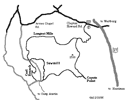
Click here for map
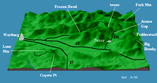
or a 3-D map (33K).
Description:
The trail leaves the parking area (1340') toward the south and
begins a gradual climb through the hardwood forest. At mile
1.4 the trail climbs very steeply through a series of switch
backs. At mile 2.1 (2000') the Longest Mile section of the
trail closes the trail loop. From this junction continue
climbing to 2280' at mile 2.6. Pass Rankin Spring at mile 3.4.
At mile 3.8 take the spur to Coyote
Point (2120') for good views south into the Tennessee
Valley. The ranger has provided picnic tables and hitching
posts for your steed. Return to the main trail and begin the 3
mile descent. At mile 5.8 the trail crosses Hall Branch Creek
several times before intersecting a gravel road at mile 6.8.
Continue down the road to where the trail heads up bumpy Carl
Branch Spur (1020') through a beautiful hemlock forest.
The trail crosses the gravel road again at mile 8.8 (1500')
and begins the fast Longest Mile section (2.7 miles) to the junction with the trail from
the parking area at mile 11.5. Turn left and begin your
free-fall back to the car.
Instead of bumping up Carl Branch Spur, you
can climb the gravel road (1.4 miles), or go up the Saw
Mill trail (2.1 miles). The Saw Mill trail is a nice down
hill when starting from the junction of the Longest Mile and
the gravel road. You can make a nice 4.1 mile loop with Carl
Branch Spur (500' cumulative climb).
The
Ranger of this 3600 acre state forest developed these trails
in 1987 for horseback riders, but he is happy to have
bicyclers and hikers (no motorized vehicles). The trail has
blaze markings and signposts. If you get a chance, stop by the
Forestry Office and express your appreciation.