Catoosa
Wildlife Management
Area Bike Rides

Distance:
40+ miles
Rating: moderate
Elevation: 820' to
2340'
Maps: USGS
Quadrangles: Lancing, Cardiff, Ozone, Herbertsburg, Fox Creek,
Dorton, Harriman, Camp Austin. Maps are available at the Obed
Park office in Wartburg (423-346-6294).
Access: Catoosa Rd
west out of Wartburg (US 27), or Genesis Rd (TN 298) off of TN
62 west of Lancing
The area is usually closed
February through March and at various times in the fall and
spring for hunts. In 1999, the area is closed
Oct 2-4, 5-7, 8-10, 22-23, Nov 18-20, Dec 2-4, 16-18, and
Jan 6-8. Contact the WMA manager (800-262-6704 or
615-456-2479) for current access information.
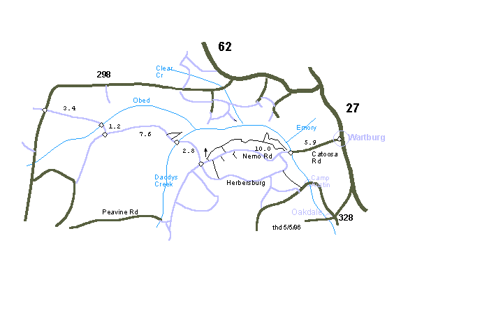
Click here for map.
Description:
The Catoosa Wildlife Management Area occupies 80,000 acres on
the Cumberland Plateau. The area is administered and owned by
the Tennessee Wildlife Resources Agency, funded by hunters and
fisherman. Catoosa is laced with gravel and dirt roads and
some single track. Numerous whitewater streams (Obed, Emory,
Clear Creek, Daddy’s Creek, Whites Creek, and Crab Orchard
Creek) cut canyons and gorges through the sandstone. There are
numerous spur trails to overlooks on the sandstone cliffs and
a few loops.
On Nemo Rd. (1850') just a mile east of the
Buck Switch junction with the road to Daddy's Creek (or about
8 miles from Nemo Bridge), there is a road that leads north
0.5 miles to the Pilot Knob fire tower (2050'). Halfway up
this road, an ATV track heads northeast 8.4 miles along Hatfield
Mountain and descends steeply to the campground at Nemo
bridge (860'), or you can take a right after 2.7 miles and
exit back to Nemo Rd, or at mile 4.5 you can take a right and
descend 3 miles to Nemo Rd (the gravel road just above the
campground gravel road).
At mile 1.5 along Hatfield Mountain, a left
descends (gnarly) .7 miles and then heads west up Turkey
Creek. In another 1.6 miles this jeep road joins the
gravel 1 mile south of the Buck Switch intersection. (Winter
of '98 storms have made the Turkey Creek section impassable as
of June '98.)
There are several ATV trails southeast of
the gravel between Island Creek and the Bicolor checking
station, some interconnecting with the jeep roads to Camp
Austin. Clark Cemetery ATV trail descends 2.2 miles from Camp
Austin road to White Oak Rd., then west 4.5 miles to Bicolor,
then east 2.8 miles to close the 10 mile loop.
