 |
|
||
|---|---|---|---|
|
|
|||
|
|
|||
|
Daddy's Creek
The distance from Meridian Bridge to US 70
is 5 ½ miles. The gradient is 4-5 ft. / mile long pools are
broken occasionally by small shoals. The 5 miles between US 70 and Center Bridge, north of
Crab Orchard, have a gradient of 10 ft. / mile.
There are Class I rapids above Center Bridge.
The nine miles from Center Bridge to Antioch Bridge
contains Class I rapids in the first portion.
The last 3 miles have a 20 ft. / mile gradient with
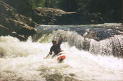
some Class II rapids. The most difficult run on Daddy’s Creek
begins at Antioch Bridge and ends at the low bridge at the
Devil’s Breakfast Table in the Catoosa Wildlife Management
Area. Below Antioch
Bridge, there is no easy access to the canyon except for a
steep foot trail from the mouth of Yellow Creek. The gradient is 34-40 ft. / mile from the
Antioch Bridge to Yellow Creek junction with rapids to Class
III. Below Yellow Creek, the gorge narrows and the pitch increases to 64
ft. / mile with stretches up to 100 ft. / mile. Large boulders
and steep complex rapids create Class II-IV rapids.
This 7 mile stretch is for experts only. Portages are rather difficult because of large boulders lining the
stream bank.
Below the junction of Daddy’s Creek with the Obed (Obed Junction), there is a steep road on the north bank of the Obed. There are hiking trails down both sides of Daddy’s Creek to its junction with the Obed.
|
||||
 The uppermost put-in is at the US 127 bridge
near Big Lick. The stream meanders its way to Linary.
The uppermost put-in is at the US 127 bridge
near Big Lick. The stream meanders its way to Linary. From the Devils Breakfast Table to the
junction with the Obed, the course eases to a gradient of 24
ft. / mile with some interesting Class III rapids.
From the Devils Breakfast Table to the
junction with the Obed, the course eases to a gradient of 24
ft. / mile with some interesting Class III rapids.|
© 1999 -
2000 Tennessee Paddle, All Rights Reserved |
|
