The
Crooked Fork
of the Emory River

The
Crooked Fork is a nice whitewater gym located just outside of
Wartburg, TN in beautiful Morgan County. The river begins its
journey in the scenic Frozen Head State Park and drains the
valley in which the town of Wartburg is located. Here it
meanders, slowly twisting and turning through valley forest
and farmland.
Hwy
27/29 is the starting point for the entire Crooked Fork run. 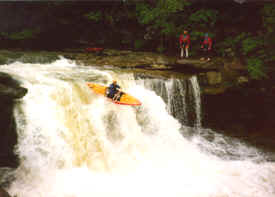 Shortly
after entry a distinct horizon line appears. This is Lamance
Falls, a 25-30 foot plumment. While Lamance Falls has been run, it is not recommended because of the
rock shelf at the base of its first big plummet. A missed line could produce a compression fraction.
Stop well above the drop, scout carefully, and make
your own decision about running it. Portages are not easy, but
can be accomplished on either side of the river.
Shortly
after entry a distinct horizon line appears. This is Lamance
Falls, a 25-30 foot plumment. While Lamance Falls has been run, it is not recommended because of the
rock shelf at the base of its first big plummet. A missed line could produce a compression fraction.
Stop well above the drop, scout carefully, and make
your own decision about running it. Portages are not easy, but
can be accomplished on either side of the river.
Now
you are in a nice upper gorge where the river is just
beginning to carve threw the strata. These next 1.5 miles
contain most of the whitewater as the river drops
approximately 160ft. Some nice III-IV boulder gardens await
you after the Lamance, providing some good warm up for
what’s to come. Soon, Potters Falls road will appear along
with yet another horizon line. Upper Potters Falls is a
classic southeastern drop of some 15-17 ft in height depending
on water levels. Upper Potters was among the first waterfalls
to be run in the south because of the known deep pool that
awaits you below. It can be run from center all the way to
river left. While you’re at it, don’t be scared to venture
behind the falls for some cheep thrills.
Lower Potters is next on the hit list. It is
best to stay river left for these drops, taking note not to
peton! Both Upper and Lower Porters can be walked/scouted on
river right. Some good solid class III-III+ awaits you for the
rest of the journey. At one point, the Crooked Fork takes a
break and meanders through some class II. Remnants of an old
homestead can be seen in this stretch. Don’t loose faith
though, the Crooked Fork has a nice ending punch before it
hits the mighty Emory. Float the Emory for a few miles down to
the take out at the Camp Austin Bridge. Look for levels of
3,500 and up for good fun on the Crooked Fork.
Water
quality has been a big issue for this watershed because it
drains Wartburg and Brushy Mountain State Prison. The stream
often has a distinct smell, giving many paddlers reason enough
not to come back and run the river. It should not be
considered any worse than other southern rivers. Supporting
Tennessee Paddle 2K can help in confronting these water
quality issues that surround the Obed/Emory system.
Recap:
| Put in |
Hwy
27/29 bridge or Potters |
| Take Out |
Camp
Austin Bridge on Emory River |
| Class |
III-IV+
(excluding Lamance) |
| Length |
6.5 miles |
| Gradient |
total:
280 ft. in 4.5m
160
ft. in first 1.5m
2m
on Emory
|