 |
|
||
|---|---|---|---|
|
|
|||
|
|
|||
|
The Obed
From US 127, the next road access is Adams
Bridge on Genesis Road (State Route 298) a distance of 10
river miles. The gradient is unevenly distributed over these
10 river miles. The
first 2 miles have a 12-15 ft. / mile gradient producing Class
I-II rapids. The next
mile has a gradient of over 60 ft. / mile, and the following 2
miles including Gould’s Bend, drop more than 70 ft. / mile.
There is a HALF-MILE STRETCH WITH A GRADIENT OF 100 FT.
/ MILE. These gradients produce rapids to Class IV to V depending on flow.
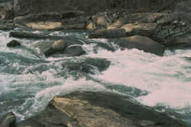
This is the steepest section of the Obed.
The river is very narrow and strewn with large
boulders, and the drops are steep and twisting.
The only other access to the gorge is by foot. After Gould’s Bend the
gradient eases to 20 ft. / mile with pleasant Class I-II
rapids. Below Adams Bridge, the
gradient is 10 ft. / mile to Potter’s Ford Bridge in the
Catoosa Wildlife Management Area.
There is a steep, 1-mile section of this 4 ¼ mile
distance, however. The
rapids in this 1-mile section are narrow, twisting drops
strewn with boulders. There
is a rudimentary trail from Adams Bridge to Potter Ford
Bridge.
The next section to the junction with
Daddy’s Creek (Obed Junction) is 4 miles. Here the Obed
doubles its size. The 4 ½ miles from Obed Junction to the
junction with Clear Creek are characterized by short, steep,
twisting drops (Class II-IV) followed by short pools. At
higher flows, the pools are very short indeed! The average
gradient is 30 ft. / mile. With the addition of the flow from Clear
Creek, the size of the Obed increases markedly.
After a half mile of Class II-III rapids, there is a
long pool known as “Canoe Hole”.
On the left bank of this pool, there is a steep trail
to the top of the gorge. It should be mentioned that roads leading to civilization are
more easily found from the left bank, particularly below Adams
Bridge. For the next 2
miles, there is a series of Class I-II rapids.
From the end of these rapids to the junction with the
Emory, the river is rather quiet. Along these stretches.
There are trails from the left bank to the top of the gorge;
in particular, the one at Alley Ford is used by fishermen. The
junction with the Emory is easily seen because of strip mining
activities, the railroad, and the turn of the river sharply
toward the southeast.
|
||||
 The Obed emerges from Lake Holliday near
Crossville and passes under US 70 S. From there it flows under
Bishop Bridge on US 127 north of Crossville.
The Obed emerges from Lake Holliday near
Crossville and passes under US 70 S. From there it flows under
Bishop Bridge on US 127 north of Crossville.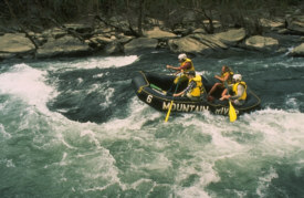 Beyond Potter Ford Bridge, the gradient
increases to 20 ft. /mile; the rapids are Class I–II, but
some are rather steep. The distance to lower Potter Ford is 10
miles. There is no road access at lower Potter Ford, only a
foot trail.
Beyond Potter Ford Bridge, the gradient
increases to 20 ft. /mile; the rapids are Class I–II, but
some are rather steep. The distance to lower Potter Ford is 10
miles. There is no road access at lower Potter Ford, only a
foot trail.|
© 1999 -
2000 Tennessee Paddle, All Rights Reserved |
|
