 |
|
||
|---|---|---|---|
|
|
|||
|
|
|||
Mtn Bike Rides
|
Black Mountain Bike Rides
Distance:
30+ miles
Click here for map
... good luck and also
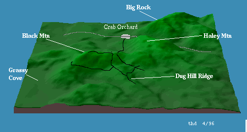
a 3-D map (24K). Description:
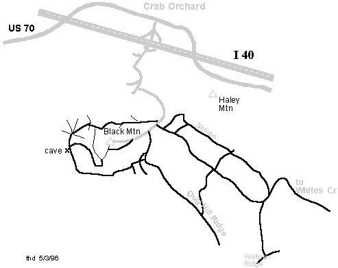
This is a popular hiking (Cumberland Trail) and rock climbing
area. Off-road vehicles frequent the area, and there is a maze
of jeep roads and ATV trails, making navigation difficult.
Much of the land is private, so obey signs. A nice starter loop (6.5 miles) is to park
at Owl Roost Gap (2320') (where a jeep road descends off to
the east). From the Gap ride back down the pavement 0.3 miles
and take the jeep road going west along the north face of
Black Mountain. This face is covered with wild flowers in mid
to late April. At mile 0.6 pass a jeep road descending right.
At mile 1.3 pass a jeep road climbing left. At mile 1.9, the
jeep road intersects the Cumberland Trail (white blazes) that
has descended 1.2 miles from the mountain top. Turn right and
go down the Cumberland Trail to the 4-way intersection at mile
2.1. Go left down the nice descent to the 6-way intersection
(1930') at mile 2.7. Take the left (at "10 o'clock")
and descend and cross a creek and visit Windless cave at mile
3.0 (1890'). (A trail from the left at the creek crossing has
descended 1.8 miles from the mountain top. Note that the cave
is the drain for a large sink hole.) Continue climbing on past
the cave, and at mile 4.9 you arrive at a clearing with lots
of downed trees. Take the ATV track to the left and climb up
to a 4-way intersection at mile 5.2. The road to the left goes
back to the pavement, continue straight (east) to the
intersection with Dug Hill Ridge road at mile 5.3. You can
turn left and climb 1.1 miles to the pavement (go right at the
next intersection). To extend the ride, turn right and zoom down
Dug Hill Ridge to mile 6.9, where you take a sharp left and
descend down to Sandy Creek and then push up the other side to
a 4-way intersection in a clearing at mile 8.5 (1940'). The
road to the right takes you toward Basin Rock/Falls and on to
Whites Creek. Turn left and climb 1.7 miles back to the Gap,
or go straight ahead and take a left in 0.8 miles at the next
4-way (1940'), and climb The Shinbone 1.1 miles to 2500'. At
the top you have views to the North, bear left and descend
back to the dirt road 0.1 miles from the Gap. You can ride the single track from the towers through the crack in the cap rock and follow Cumberland Trail to Windless Cave. With a shuttle car east of White's Creek on Black Creek Road off of US27, you can ride 15 miles from Black Mountain through Dogwood and down the old stage road. You have to cross (wade/swim) White's Creek, so pick a dry time of the year. This is just a sampling of the trails of Black Mountain. |
||||
|
©
1999 - 2000 Tennessee Paddle, All Rights Reserved |
|