Home Feedback  

 Daddy's Creek 

You need a Java enabled browser!

2001 Events
Urgent Alerts
What's Up?
Camping and More
Race 2001
Our Sponsors
Volunteer
Trips and Runs
Donate
Conservation
Access to Catoosa
Rivers 2000
The Rivers
Clear Creek
Crab Orchard
Crooked Fork
Daddy's Creek
The Emory
The Obed
White Creek
Caney Fork Dam
Biking
Rock Climbing
Hiking The Trails
Write 'em
About AW
Media Center
The Map
Wartburg TN
Morgan County
Paddle Chat & More
River Tunes
Links and Friends
Contents
Search

  Trips and Runs
Crooked Fork
Daddy's Creek
DBT to Nemo
Gould's Bend
Island Creek
Jett to Lilly to Nemo
Monte Smith


Daddy's Creek Canyon

Daddy's CreekThis 6 ½ miles in Daddy’s Creek Canyon is the most difficult of the frequently paddled sections of the system. It flows through a spectacular canyon, features a two mile stretch of intense water, and harbors nightmare undercut rock formations. Like big, house sized boulders? Here they are!


The Run Where
Put in at Antioch Bridge Peavine Road Exit off I-40 Crossville
20 feet per mile gradient 0.0 to 1.0
60 feet per mile gradient  1.0 to 2.0
20 feet per mile gradient 2.0 to 4.0
Yellow Creek on river right 3.5
Yellow Creek Canyon 3.6 to 5.5
Spike (III+) 4.1
Fang of the Rattlesnake 
(III+ to IV+)
4.2
Rocking Chair or Tree 
Rapid (III+ to V)
4.5
Continuous Rapids 4.5 to 6.0
Takeout at Devil’s Breakfast
Table
Or Obed Junction 
(add 2 miles) if Catoosa Wildlife Management Area road is closed.
6.5

NOTE: At 4.1 River right is undercut and at 4.5 undercut rock on river left.

Suggested Flow
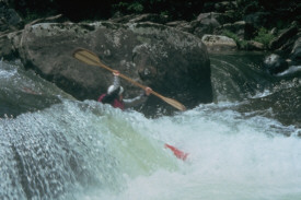
Low Medium Advanced Gauge
1,200 cfs 3,000 cfs 5,000+ cfs Emory at Oakdale
1.2 ft 1.6 ft 2.0 ft Antioch Bridge

Back Home Up Next

© 1999 - 2000 Tennessee Paddle, All Rights Reserved
Site Development and Hosting by
WebWeavers Internet Services

Click for Wartburg, Tennessee Forecast