 |
|
||
|---|---|---|---|
|
|
|||
|
|
|||
Trips and Runs
|
The Crooked Fork Run
Crooked
Fork Creek, a tributary of the Emory River, begins its journey
in scenic Frozen Head State Park, near Wartburg, TN.
Soon it begins threading through rock gardens and then a distinct horizon line appears. This is Lamance Falls, a 25-30 foot plummet. While Lamance Falls has been run, it is not recommended because of the rock shelf at the base of its first big plummet. A missed line could produce a compression fraction. Stop well above the drop, scout carefully, and make your own decision about running it. Portages are not easy, but can be accomplished on either side of the river. Below
Lamance, the stream drops some 160 feet in just over a mile.
This distance is studded with several III-IV boulder
gardens, as well as two memorable waterfalls.
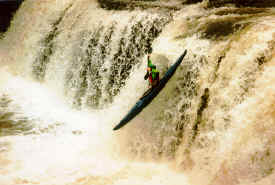
The first is upper Potters Falls, a classic
southeastern drop of some 15-17 feet, depending on water
level.
Run this drop, which has a deep and hospitable catch
pool, anywhere from the center of the stream all the way to
river left. A
mere 150 yards downstream, look for Lower Potters Falls, a
drop that is decidedly less user-friendly than its upstream
counterpart.
Scout or walk on river right and run it (if you must)
down the left, where a piton is possible even at favorable
water levels.
Rock formations on river right can be appreciated only
at lower flows (which is not when paddlers will be on the
river), but take it on faith that they form a potentially
fatal sieve. Crooked
Fork’s final miles are through a deep, broad-floored canyon.
Most of this section is festooned with class III-III+
rapids, but in the midst of this happy mayhem, On Crooked Fork, one or two rapids between Lamance and upper Potters are Class IV, everything else on the river is III. Except the waterfalls. Lamance is nasty if you miss your line, with a slab-rock landing. Upper Potters is like falling off a log. (A big log.)
Takeout at Camp Austin on Emory River (river left side) upstream of Oakdale. Suggested FlowDepending on season, rainfall intensity, and duration, the following gauges may not correlate.
|
||||||||||||||||||||||||||||||||||||||||||
 After
leaving the park it meanders uneventfully for several miles,
passing through farmland and valley forest. Then, about three
miles south of Wartburg, it crosses under US Hwy 27/29, and
the fun begins.
After
leaving the park it meanders uneventfully for several miles,
passing through farmland and valley forest. Then, about three
miles south of Wartburg, it crosses under US Hwy 27/29, and
the fun begins.|
© 1999 -
2000 Tennessee Paddle, All Rights Reserved |
|
